Log in
All resources
Create a design
947 Free Artworks of Maps Of The Netherlands
gemeente atlas van nederland - south holland
1860s maps of south holland
bibliothèque nationale de france
atlas novus (blaeu)
gemeente atlas van nederland - north holland
1860s maps of north holland
maps by isaak tirion
isaak tirion
maps by pieter van der keere
maps with cartouches
maps of hulsterse bolwerken
old maps of hulst
maps by pieter van der keere
maps by abraham ortelius
sanson maps of the netherlands
maps by alexis-hubert jaillot
maps of aa en hunze
gieten
maps by isaak tirion
1751 maps
gemeente atlas van nederland - south holland
1860s maps of south holland
maps by willem and johannes blaeu
old maps of breda, netherlands
1645 maps of belgium
tournaisis
19th-century maps of south holland
netherlands in the 1860s
1640s maps of the netherlands
coats of arms on maps
maps of the united kingdom of the netherlands
1810s maps of the netherlands
illustrated title pages
1645 books
old maps of brabant
1666 in belgium
gemeente atlas van nederland - south holland
1860s maps of south holland
old maps of regions of france
county of artois
gemeente atlas van nederland - north holland
19th-century maps of amsterdam
hoogheemraadschap van rijnland
maps of woubrugge
maps of gouda by braun & hogenberg
hollandse ijssel in gouda
old maps of roermond
upper guelders
gemeente atlas van nederland - south holland
maps of geervliet
maps with figures
michael burghers
1748 maps of the netherlands
1740s maps of belgium
maps by willem and johannes blaeu
new amsterdam
gemeente atlas van nederland - south holland
old maps of katwijk, south holland
gemeente atlas van nederland - south holland
1860s maps of south holland
old maps of bredevoort
maps by isaak tirion
history of alphen aan den rijn
maps of aarlanderveen
sanson maps of the netherlands
1700s maps of the netherlands
1610s maps of the netherlands
maps with cartouches
gemeente atlas van nederland - south holland
1860s maps of south holland
copper engravings
maps by hattinga
gemeente atlas van nederland - south holland
maps of wateringen
maps of territories in the burgundian circle
17th-century maps of the north sea
old maps of grave, netherlands
atlas van loon
sconces in the netherlands
maps by isaak tirion
old maps of north brabant
1645 maps of belgium
gemeente atlas van nederland - south holland
19th-century maps of rotterdam
gemeente atlas van nederland - south holland
19th-century maps of rotterdam
gemeente atlas van nederland - south holland
1860s maps of south holland
gemeente atlas van nederland - north holland
old maps of haarlem
gemeente atlas van nederland - north brabant
maps of putte, netherlands
sanson maps of the netherlands
1680s maps of the netherlands
maps by willem and johannes blaeu
old maps of kampen, netherlands
maps by john cary
1799 maps
maps by willem and johannes blaeu
maps of the duchy of limburg
old maps of westerwolde
maps of vlagtwedde
gemeente atlas van nederland - south holland
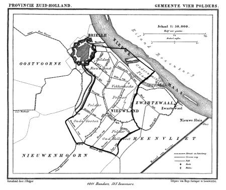
old maps of brielle
maps from university of amsterdam special collections
atlas der neederlanden
gemeente atlas van nederland - north brabant
demen
old maps of the hague
old maps of delfland
gemeente atlas van nederland - south holland
maps of 's-gravenzande
gemeente atlas van nederland - south holland
1860s maps of south holland
gemeente atlas van nederland - south holland
maps of hellevoetsluis
maps in the rijksmuseum amsterdam
published by frans buffa & zonen
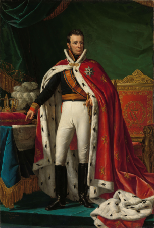
william i of the netherlands (joseph paelinck - rijksmuseum amsterdam)
1819 portrait paintings of men
maps in the rijksmuseum amsterdam
published by frans buffa & zonen
old maps of schouwen-duiveland
maps by isaak tirion
gemeente atlas van nederland - south holland
old maps of dordrecht
gemeente atlas van nederland - south holland
maps of alkemade
gemeente atlas van nederland - south holland
old maps of gorinchem
gemeente atlas van nederland - south holland
maps of maassluis
gemeente atlas van nederland - north holland
maps of haarlemmermeer
old maps of the hague
old maps of delfland
gemeente atlas van nederland - south holland
maps of stompwijk
maps of hooge zwaluwe
maps of lage zwaluwe
maps of waterways in the netherlands
de zegepraalende vecht
gemeente atlas van nederland - south holland
19th-century maps of rotterdam
gemeente atlas van nederland - south holland
1860s maps of south holland
gemeente atlas van nederland - south holland
1860s maps of south holland
gemeente atlas van nederland - south holland
maps of groote lindt
gemeente atlas van nederland - south holland
1860s maps of south holland
gemeente atlas van nederland - south holland
1860s maps of south holland
maps from university of amsterdam special collections
atlas der neederlanden
atlas van der hagen (volume 2)
1680s maps of the netherlands
gemeente atlas van nederland - north holland
old maps of beverwijk
old maps of north brabant
maps of megen
17th-century paintings of soldiers
lambert de hondt (ii)
maps by pieter van der keere
old maps of utrecht
maps by pieter van der keere
1610s maps of belgium
maps of groningen by braun & hogenberg
maps of gorinchem by braun & hogenberg
gemeente atlas van nederland - south holland
1860s maps of south holland
gemeente atlas van nederland - south holland
1860s maps of south holland
gemeente atlas van nederland - south holland
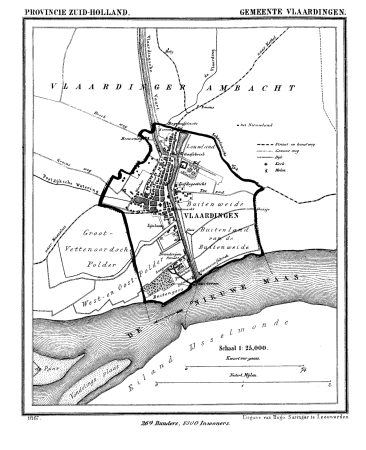
old maps of vlaardingen
gemeente atlas van nederland - south holland
1860s maps of south holland
gemeente atlas van nederland - south holland
1860s maps of south holland
16th-century maps of the netherlands
16th-century maps of belgium
gemeente atlas van nederland - south holland
1860s maps of south holland
gemeente atlas van nederland - north holland
19th-century maps of den helder
gemeente atlas van nederland - north holland
old maps of haarlem
gemeente atlas van nederland - drenthe
drenthe
18th-century maps of zeeland
maps by isaak tirion
1640s maps of the netherlands
coats of arms on maps
gemeente atlas van nederland - south holland
1860s maps of south holland
gemeente atlas van nederland - groningen
maps of noordbroek
18th-century maps of zeeland
maps by isaak tirion
maps by pieter van der keere
old maps of north brabant
maps in the phoebus foundation
maps by pieter van der keere
breda, netherlands in the 17th century
old maps of north brabant
gemeente atlas van nederland - north holland
19th-century maps of amsterdam
gemeente atlas van nederland - north holland
amsterdam in the 1860s
201 - 300 of 947
Next page
/ 10